Forecasters: It's going to be a wet and windy 2013


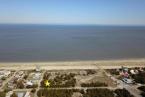
Early forecasts are predicting an increased number of hurricanes for the 2013 season, meaning more flooding, storm damage and beach erosion for coastal Sussex.
Center for the Inland Bays Executive Director Chris Bason says the news is both good and bad for Cape Region ecosystems.
Hurricane season is June 1 to Nov. 30. During the spring and early-summer months, farmers are in the middle of growing season. With new crops and fertilizer in the fields, an early season hurricane can wash excess nutrients into the bays, leading to algae blooms and fish kills, Bason said.
“After a big storm like that, all the bays are really murky and sediment laden, often for weeks at a time,” Bason said. “This prevents bay grasses from growing and can be a real stress on the bay.”
While more storms will create problems, Bason said, there is also a positive side.
“During a hurricane, often you get a breech in the dunes, and the water washes sand over and spreads it into the bays. That actually helps sustain the marshes,” Bason said. “Without that function, the marshes would drown.”
Colorado State University Department of Atmospheric Science researchers, who released an early forecast April 10, estimate that 2013 will have about nine hurricanes, a third more than usual. Forecasters are predicting 18 named storms, 95 named storm days; more than double the number of hurricane days with 40; and four major Category 3, 4, or 5 hurricanes.
The tropical Atlantic has become unusually warm, and it appears that the chances of an El Niño event this summer and fall are unlikely, write the researchers in the study. “Coastal residents are reminded that it only takes one hurricane making landfall to make it an active season for them.”
Dr. Jeff Masters, cofounder of Weather Underground in 1995, and a former hurricane chaser with The National Oceanic and Atmospheric Administration, said April forecasts are generally unreliable.
“The forecasters are using a statistical model developed in 2011 for making April forecasts, so we don't have a long enough track record to judge how good the new model is,” writes Masters in his blog at wunderground.com. “The new model predicted a below-average year for 2012, with 10 named storms, 4 hurricanes, and 2 intense hurricanes. The actual tally was much higher, with 19 named storms, 10 hurricanes, and 2 intense hurricanes.”
Masters said predicting storms in April has to include a lot of data, much of which is unknown. During April, temperatures and wind patterns are beginning to change, both of which have a great impact on the type and size of summer and fall storms.
“For now, these April forecasts should simply be viewed as an interesting research effort that has the potential to make skillful forecasts,” says Masters, adding that the Colorado researchers' June forecast is more reliable. That forecast is due Monday, June 3.
Bason said hurricanes can increase runoff to the environmentally sensitive Inland Bays.
“Runoff sweeps in more chemicals from the land and results in a pulse of pollution coming into the system,” Bason said.
In the past, there's been evidence that big storms have tipped an ecosystem over the edge, Bason said.
“There's a level of stress the ecosystem can handle. These storms can act as a trigger to knock an ecosystem down,” he said.
Increased nutrients and bacteria in the water after Hurricane Sandy caused a temporary closing of shellfish harvesting last year. “That's a big deal; that puts people out of work,” Bason said.
“Cleaning up after hurricanes takes time and money,” Bason said. “Even now, there is a lot of trash in the bays from Hurricane Sandy. We expect this year during our annual clean-up to see a lot more debris than past years.”
Other forecasters are also predicting an active season. Private weather firm WSI (part of The Weather Company, along with The Weather Channel, Weather Central, and The Weather Underground), is forecasting 16 named storms, nine hurricanes and five intense hurricanes. British forecasting firm Tropical Storm Risk, Inc. expects 15 named storms, eight hurricanes and three intense hurricanes.
Delaware Department of Natural Resources and Environmental Control Secretary Collin O'Mara did not return requests for comment.
Behind the forecast
The Colorado team gave two reasons for the prediction of an active season:
• El Nino. Conditions from the El Nino wind pattern are expected to be neutral again this year. In the past, El Nino's winds in the upper atmosphere stopped hurricanes before they formed.
• Water temperatures. Rising water temperatures add fuel to the hurricane fire. Unusually warm temperatures can allow more hurricanes to form and also allow them to travel farther, hitting land where if temperatures were colder, they might not.
“Everyone should realize that it is impossible to precisely predict this season’s hurricane activity in early April,” said researchers, who provide the early forecasts to appease the public's curiosity.