Harbor Point flooding remains issue for Lewes planners

Potential flooding in the proposed Harbor Point subdivision remains at the top of the list of concerns for the Lewes Planning Commission.
The board met with developer Jack Lingo Asset Management July 22 to seek answers to its most burning questions as it nears a decision on preliminary consent.
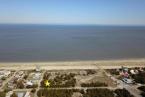
The developer is seeking to build 69 single-family lots on a 108-acre parcel of land off Park Road. The land borders the Canary Creek community to the east and the Great Marsh and wetlands on the other three sides. The land sits in Sussex County, but it would be annexed into Lewes as part of the subdivision approval process.
Commissioner Barbara Vaughan pointed to critical comments by the Department of Natural Resources and Environmental Control in its report to the state planning office's Preliminary Land Use Service review of the Harbor Point parcel. In the short term, DNREC says, sea-level rise on the parcel combined with periodic coastal flooding events may result in repetitive flood damage to homes and significant difficulties maintaining stormwater and drainage infrastructure. In the long term, increased flood and inundation risk could result in costly public and private flood-abatement and drainage projects and possible abandonment of homes.
“That is a pretty strong statement,” Vaughan said.
Ring Lardner, principal and professional engineer with Davis, Bowen and Friedel, said the developer has committed to building all roadways and homes at or above the Federal Emergency Management Agency's current 100-year flood elevation. While the base flood elevation FEMA uses for its flood maps is expected to drop by a foot when new maps are adopted later this year or early next year, he said, the developer will stick with the higher elevations for Harbor Point. No basements will be permitted, he said. Crawl spaces or slab-on-grade foundation will be the design, he said, and homes will be built at the current 100-year flood level.
Fill will be used to raise homes and roadways to required levels, and a 50-foot buffer will be in place between the edge of a homeowner's property and wetlands, Lardner said. The first 25 feet of the buffer will be undisturbed land. The remaining portion will be part of the community's open space and will be used to gradually build the land up to required heights.
Commission Vice Chairwoman Kay Carnahan said she is still struggling with allowing the developer to build so close to the Great Marsh.
“Are we encouraging people to live in places that are unsafe?” she said. “We're not frozen in time. What is our responsibility to people moving to this community? That's the question we have. That was a stopper to me. We've never had anything that clearly stated.”
Gene Bayard, the developer's attorney, said new residents know the risks.
“I've got to believe that people who buy property in this area have some idea of what they're buying,” he said. “I think they're drawn to the coast for a reason. I think they're drawn to Lewes for a reason. They are aware of the location of the Great Marsh, the Broadkill River, the Delaware Bay, Canary Creek. They can figure all these things out.”
Lardner said both Lewes' city code and FEMA allow for development in floodplain areas, and Harbor Point will be built to those standards. Measures have been taken to control stormwater, he said, including a stormwater pond and several bioswales. At least one bioswale will be placed between Harbor Point and Canary Creek to ensure potential flooding does not find its way into the neighboring community.
The planning commission has now collected all pertinent information to make a decision, which is expected to come at the group's regular meeting Wednesday, Aug. 20.