Lewes planners discuss wetland buffers

The Lewes Planning Commission has made it clear it’s important to protect wetlands. How to go about that is the challenge they are now facing. “I’m not sure we can ever come up with a lot-by-lot plan that’s going to be applicable across the city, but I think we need to do something more than what we have now,” said Chairman Drew McKay.
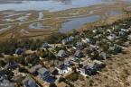
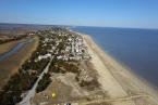
The city has no existing wetland protections in place. A 50-foot buffer was included in the city’s recently passed annexation zones, but applies only to land currently outside the city.
Tom West, the city’s planning and development coordinator, said the planning commission will have to work diligently over the next several months to find what will work best for Lewes. “We really need to understand how different designs would work in different locations in the city based on what type of wetlands there are and what types of adjacent land uses there are,” he said.
He said a one-size-fits-all approach likely will not work in Lewes because wetlands along Lewes Beach are not the same as wetlands along Canary Creek or other areas. He said it’s also important to adequately express why the commission wants to establish wetland protections. He said other towns, counties and states establish buffers and protections for a variety of reasons, including protection from unwanted pollution and nutrients, preserving wildlife habitat or to defend from flooding during a storm event. Flooding is definitely a concern for Lewes, he said.
“Using our wetlands to help maintain or hold flood waters and give us a buffer during storm events is what our hazard mitigation plan says in several places,” he said.
Commissioner Tom Pannetta agreed flood mitigation is of utmost importance. “I think the main priority is flooding and health of the marshes to absorb storm energy,” he said. “If you look at studies that came out of Staten Island after Sandy, Houston [after Harvey] and what’s happened in Louisiana, it’s all about the health of the marshes to dissipate storm energy.”
Commissioner Kay Carnahan said it’s also about protecting the people who live in flood-prone areas. “If you don’t know what you have on your property, then you’re going to find out during a really bad storm,” she said. She pointed to the recent study of city-owned property along the marsh on Lewes Beach, where city officials sought to determine if certain properties were available to sell. “Once the [wetland] delineation was done, a decision was made that these lots were too wet to sell,” she said. “That’s going on in a lot of places, and people need to know that.”
Commissioner Nina Cannata said Lewes and the entire Delaware coast have been lucky to have been spared from a direct hit by a hurricane over the last century. She said that luck won’t last forever, and Lewes needs to be prepared. “It’s going to make some people unhappy, but safety should be tantamount in some of this,” she said. “We’re so low-lying that when it hits us with the speed of a Florence, it’s going to be water all the way out to Route 1. I think that’s something we need to get across.”
Resident Rick Quill was one of only a few people who attended the meeting. He urged the commission and city officials to improve transparency when they are considering land-use changes that could potentially significantly affect people’s property. He said posting a meeting notice in accordance with Freedom of Information Act requirements is not enough. He urged officials to send a certified letter to each property owner potentially impacted.
One of the concerns Councilwoman Bonnie Osler had at the commission’s Aug. 19 meeting was the loss of use and value of many properties on Lewes Beach. The commission, in its initial recommendation of a 50-foot buffer to council, tried to build in a workaround by including language that said buffers would apply to all properties unless they would deny reasonable use. Existing homes and structures would also be grandfathered under the initial proposal.
In doing additional research, Pannetta found an ordinance in Alachua County, Fla., that he said would translate well to Lewes. “I think it’s an extremely good template to work from because it sets minimums, maximums and it has criteria that can be used to judge,” he said. “It also protects the property owner from a taking of use.” He said it’s particularly applicable because it doesn’t follow a one-size-fits-all approach to buffers.
In terms of an appropriate buffer width, McKay referenced a study in a National Wetlands newsletter that found buffers less than 50 feet were much more susceptible to degradation by human disturbance. The same report, which studied 21 established buffers in two Washington counties, found that no buffer of 25 feet or less was functioning effectively.
Adding a layer of difficulty to the buffer discussion are the state’s outdated wetlands maps. City Manager Ann Marie Townshend said she recently spoke with Steve Smailer of the Wetlands and Subaqueous Lands Section of the Department of Natural Resources and Environmental Control. Smailer told her the wetland maps were adopted in 1988 and have likely changed significantly over the last three decades.
“That is one of the challenges,” Townshend said. “If you’re buffering what’s on state tidal wetland maps, it’s very likely the actual wetlands are bigger than what your 50-foot buffer would be.”
Tidal wetlands are regulated by the state and DNREC, while nontidal wetlands are the responsibility of the U.S. Army Corps of Engineers. Neither agency regulates buffers. “It’s a land-use matter, and zoning is at the local municipal level,” West said. “It’s not that they haven’t advocated for it, but they’re suggesting through case law that it’s done at a local level.”
The commission is not expected to make a new recommendation to city council in the next few months, but the issue will appear on the agenda for discussion at each of the commission’s upcoming meetings. To view agendas for upcoming meetings, go to ci.lewes.de.us and select Agendas & Minutes from the tab on the left side of the page.