Land swap at center of rezoning denial

A land swap that paved the way for the new Lewes Public Library is now at the heart of a zoning dispute.
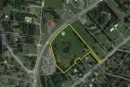
Mayor and city council voted 3-2 Sept. 11 to deny Jerome Virden’s request to rezone a portion of his property from R-2, low density, to R-4, medium density. Since the 2015 land swap where Virden acquired a .32-acre section of land to square off his property and gain access to Kings Highway, the parcel has had two different zonings – R-4 for the acquired tract and R-2 for land he had already owned.
Virden says that if he had not executed a land swap with Thompson & Thompson LLC, the library property would never have been sold to the city, and the library would not have been built. Virden also provided a sewer easement through his property for the new library, and he did not seek any compensation.
“If I hadn’t backed off and signed some papers real quick, the library wouldn’t exist,” he said. “You’d have houses there.”
A point of contention for Virden and his attorney, Vince Robertson, is that until recently, the library property was zoned R-4, meaning Virden’s acquired land and the neighboring parcel had the same zoning classification. However, in May, council voted to rezone the library tract – property it owns – to open space, making Virden’s small sliver of R-4 an island because the land beyond is zoned R-2.
"The city has previously determined that a large parcel in this area was appropriate for R-4 and this frontage [of Virden’s property] was appropriate for R-4,” argued Robertson.
R-4 zoning exists along Kings Highway, beginning near the town center at Second Street and moving out to DeVries Circle. Virden’s property is beyond DeVries Circle, but it was directly adjacent to the 5.5-acre library property, which was R-4 before it was rezoned.
The city planning commission unanimously voted to recommend the rezoning be approved.
The majority of council did not agree. Councilwoman Bonnie Osler and Councilman Rob Morgan voted against the request, while Deputy Mayor Fred Beaufait and Councilman Dennis Reardon voted in favor. Mayor Ted Becker cast the deciding vote against the rezoning.
Osler said it is a stretch to argue Virden's property is appropriate for R-4 under current zoning.
“It’s adjacent to something that’s adjacent,” she argued.
She said the code and the city’s comprehensive plan clearly define what is appropriate for Virden's section of town.
“The basic idea was the center of town is where we wanted densely populated, smaller lots,” she said. “The idea in our comp plans was that the farther you went out, the larger the lots would become and the more suburban the setting would be.”
Density is at the heart of the discussion. Under R-2, a property owner may build with a minimum lot size of 10,000 square feet, while the minimum lot size for R-4 is 5,000 square feet.
“I don’t think this should be a place where we cram more density in such a critical part of the city’s traffic,” said Councilman Rob Morgan, who voted against the request.
Along with the parcel in question, Virden and his family own three other adjacent properties, all zoned R-2. Virden’s family has owned the property in question since 1908.
Robertson also argued that by not granting the rezoning request to R-4, Virden’s property will be nonconforming if his new, smaller section is changed to R-2 to match the zoning of the existing parcel.
Since Virden’s original property had no frontage on any roads, the addition of the new section creates an access point on Kings Highway. Under R-2 zoning, he is required to have 75 feet of frontage, but his property only has 69 feet. He argues rezoning to R-4 would alleviate this problem, because the minimum frontage requirement is only 50 feet.
Robertson said Virden is weighing his options moving forward, including legal action.
Nick Roth is the news editor. He has been with the Cape Gazette since 2012, previously covering town beats in Milton and Lewes. In addition to serving on the editorial board and handling page layout, Nick is responsible for the weekly Delaware History in Photographs feature and enjoys writing stories about the Cape Region’s history. Prior to the Cape Gazette, Nick worked for the Delmarva Media Group, including the Delaware Wave, Delaware Coast Press and Salisbury Daily Times. He also contributed to The News Journal. Originally from Boyertown, Pa., Nick attended Shippensburg University in central Pennsylvania, graduating in 2007 with a bachelor’s degree in journalism. He’s won several MDDC awards during his career for both writing and photography. In his free time, he enjoys golfing, going to the beach with his family and cheering for Philadelphia sports teams.