New citizen group questions Harbor Point

A new citizen action group has sprung up in Lewes and it has set its sights on Harbor Point.
Sussex Act Now Delaware (SAND) held its inaugural meeting Sept. 2 at the Lewes Public Library. While the group plans to tackle all development issues facing Lewes and its surroundings, most of the meeting was dedicated to the proposed 69-lot major subdivision just outside city limits.
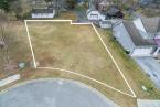
SAND invited Susan Love and Mike Powell of the Department of Natural Resources and Environmental Control to the meeting to answer some of the residents' more burning questions about the hydrology of the proposed site. Jack Lingo Asset Management plans to develop 108.75 acres between the Canary Creek community and the Great Marsh on the northwest side of New Road. The site is surrounded by marsh and wetlands on three sides.
Powell, the program manager for the Community Floodplain Codes and Ordinances section, said most of Harbor Point will be within the 100-year flood plain. That's not unusual though, he said, as most of Lewes Beach is in the flood plain.
“Large portions of coastal Sussex County are in the 100-year flood plain,” he said. “This isn't some unusual designation.”
Delaware does not have flood plain regulations, he said; that task falls on the shoulders of Sussex County and the local municipalities. Powell works with the Federal Emergency Management Agency to develop accurate flood maps. He also works with the county and local jurisdictions to develop sound flood plain regulations.
Love, a resource planner for DNREC, says Delaware has a conundrum on its hands. As sea level continues to rise by 3.35-mm each year, the state is also sinking. By 2100, her models show sea level could rise as much as 1.5 to 5 feet. Lately, she said, models indicate sea-level rise will be closer to 5 feet.
State researchers have employed a bath tub model to show what flooding could look like if these predictions come true. That model shows most of the Harbor Point site underwater.
“The model is a good indication for areas that are most at risk from sea-level rise in the future,” she said. “If someone builds a dike or a sea wall, it's going to look very different in the future.”
Some of Love's concerns were included in the Preliminary Land Use Service report about Harbor Point. A PLUS report is a summary of comments from state agencies about a specific project.
Planning Commission member Barbara Vaughan pointed to DNREC's comments in the PLUS report when discussing Harbor Point at a recent meeting. However, the commission voted unanimously to grant preliminary consent shortly thereafter.
DNREC's comments left some residents uneasy about development in that area. Some residents were concerned home buyers would be unaware of the flood risk when purchasing in Harbor Point. Powell said the state does require real estate agents to disclose specific things before selling a home; however, flood risk may not be one of them. He said there are other indicators that could educate home buyers, though, including the requirement of flood insurance or more stringent building codes for floodplain homes.
The developer has stated publicly that it will meet all requirements for building in the floodplain and will go further by building homes 1 foot higher than the minimum height required.
Bob Rosenberg, a founder of SAND, said the city's planning commission did the wrong thing in granting preliminary consent. He said the city should've let the developer take the subdivision to the county, where they would have to develop the parcel under AR-1 zoning, requiring 20,000-square-foot lots. The R-3 zoning the developer seeks in Lewes only requires 5,000-square-foot minimum lot sizes.
“It seems to us that in actuality it would be far better for this land to not be annexed and let the county deal with it,” he said.
Resident Gerald Lechliter, who has fought development in the Great Marsh area and won, agreed that the city should not seek annexation and let the developer try to build under county jurisdiction.
“The city should let Sussex County keep it,” he said. “At 20,000 square feet per lot, I guarantee there's no development there. It isn't economically feasible.”
Resident Gail van Gilder, the chair of the city's historic and scenic byways committee, said allowing Harbor Point to be built opens the doors to more development along the New Road corridor.
“Harbor Point is the tip of the iceberg here,” she said. “We need to be thinking about what happens after Harbor Point because there's a lot of open space on New Road, and we're going to be having this conversation over and over and over.”