DelDOT revises boundaries of Lewes TID
Department of Transportation officials have revised a proposed transportation improvement district they are planning for the Lewes area.
Lewes officials had previously questioned the boundaries of the district because there are only a handful of developable lots within city boundaries. The purpose of a district is to charge developers a predetermined fee for future road improvements when a project is approved. DelDOT Principal Planner Sarah Coakley said the developer’s fee is typically determined by the square footage of a development or per residential housing unit.
When DelDOT Secretary Jennifer Cohan proposed the district to Lewes council earlier this year, officials were concerned that projects approved outside the district boundary would have a negative effect on the city. Because those projects would not be within the Lewes district, developers would not be required to contribute money to improve roadways their projects would adversely affect.
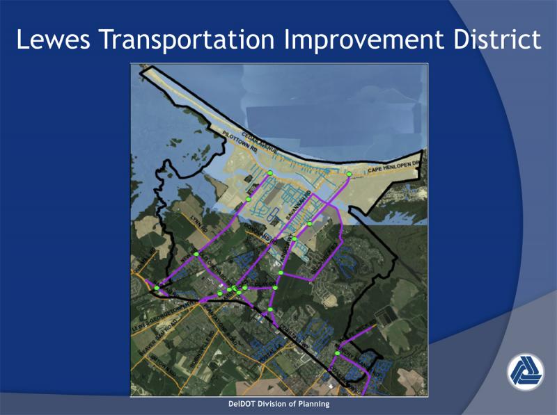
DelDOT’s revised boundaries for the Lewes Transportation Improvement District now reach out to Route 1 to the west, with a northern boundary north of New Road and a southern border containing most of Munchy Branch Road north of Rehoboth.
The revised district would fall in two jurisdictions – Lewes City Council and Sussex County Council.
“You would have to work with the county and agree on a land-use plan for the parcels that are outside Lewes,” said Coakley during Lewes council’s Oct. 16 meeting.
Another option she said would be to establish a master plan for the area, but developers would only contribute to improvements if the parcel is annexed into the city.
Coakley said a transportation improvement district offers a lower risk for developers because they know in advance how much they will pay for improvements. It also ensures improvements occur when needed because road and traffic conditions are closely monitored. Districts also speed up the approval process for developers because they are no longer required to get a traffic impact study – a six- to nine-month process. A developer’s proposed project will still have to go through the Preliminary Land Use Service for evaluation from other state agencies.
If the district were to move forward, the next step would be to establish service-level standards for intersections within the district. Based upon the standards, she said, needed improvements can be developed.
Intersections are graded on an A to F scale. F is typically an intersection where a driver waits more than 50 seconds.
DelDOT works with the local governing body to establish a standard at weekday peak hours in the morning and afternoon.
“In more rural areas, we like to see it closer to A,” Coakley said. “In more developed areas, C or even B during the peak. That would be up to the city to see what level of service it wants.”
Route 1 not included
DelDOT is simultaneously working with Sussex County Council to establish the Henlopen Transportation Improvement District, which encompasses a large section of land west of Route 1, as south as Camp Arrowhead Road and as north as Minos Conaway Road. The western boundary runs along Beaver Dam Road.
When DelDOT revised the boundaries of both districts, officials decided to leave the Route 1 corridor out of each. Coakley said that it wouldn’t be fair to developers to have to contribute funds to Route 1 now, and that the funds could be better utilized in other areas of the districts.
She said DelDOT plans to establish a working group to look at only Route 1, including Five Points.
“That would involve all stakeholders that are impacted by the current condition of Route 1,” she said. “Route 1 is not an easy fix. We think it’s better to address it separately through its own study and funding.”
C.R. McLeod, DelDOT’s community relations director, said the goal is to have the first Five Points/Route 1 meeting before the end of the year.

Nick Roth is the news editor. He has been with the Cape Gazette since 2012, previously covering town beats in Milton and Lewes. In addition to serving on the editorial board and handling page layout, Nick is responsible for the weekly Delaware History in Photographs feature and enjoys writing stories about the Cape Region’s history. Prior to the Cape Gazette, Nick worked for the Delmarva Media Group, including the Delaware Wave, Delaware Coast Press and Salisbury Daily Times. He also contributed to The News Journal. Originally from Boyertown, Pa., Nick attended Shippensburg University in central Pennsylvania, graduating in 2007 with a bachelor’s degree in journalism. He’s won several MDDC awards during his career for both writing and photography. In his free time, he enjoys golfing, going to the beach with his family and cheering for Philadelphia sports teams.