Bay coastal towns are especially vulnerable


The Atlantic Coast bore the brunt of the Storm of '62, yet those who lived along the Delaware Bay paid perhaps the highest price: Six members of one family died in Bowers and another person died in nearby Slaughter Beach.
As the storm battered the coast for five consecutive high tides, roads to the bay towns were cut off.
Lonnie Field, who grew up in Bowers Beach and has written a song about the storm, said his mother was frantic calling to him as he was getting ready for school March 6. “We looked out back and saw houses floating in the marsh,” he said. It didn't take long for the family to evacuate the area to move in with friends in Milford.
Thirteen at the time, Field said the state board of health required everyone to get a typhoid shot when they returned home. “I remember I got really sick from the shot,” he said.
He also recalls a strange event, later that spring, when state officials burned off marsh phragmites. “We heard explosions from propane tanks that had washed out into the marsh. It sounded like bombs were going off,” he said.
The events of that week are etched in Field's mind, but it wasn't until about four years ago that he sat down and wrote a song about the storm.
With his band, Sand Creek, Field has recorded “The '62 Storm” and filmmaker Michael Oates has incorporated the song and band in a music video. Oates directed, wrote and produced the film “The ’62 Storm – Delaware’s Shared Response.”
Studies of bay beach towns
The bay beach towns are the subject of extensive research through ongoing efforts by the Delaware Bay Beach Work Group and the 2011 Sea-Level Rise Initiative, both coordinated by the Department of Natural Resources and Environmental Control.
If sea-level predictions hold true, most Delaware Bay coastal communities could be underwater at some point over the next 50 to 100 years.
Using models and up-to-date survey information, officials have been able to map the impact of sea-level rise that could occur along the bay coast. Jim Eisenhardt, an environmental consultant with DNREC, said planners are using data to show what the worst case scenarios would be.
For example, with a rise in water of 1.5 feet by 2100, half of Bowers Beach would be under water; a 3-foot rise would wipe out most of the town. “And that's without a storm or spring high tide,” Eisenhardt said during a March 7 workshop to commemorate the Storm of '62. He was among eight speakers taking part in the workshop at Rehoboth Beach Convention Center.
“Most of the homes there are within the 100-year flood plain and built after the '62 storm. Most homes are at risk,” he said.
About 1,600 homes in bay communities were surveyed with the digital LiDAR ground system, which provides officials with a 3-D digital image of homes with all elevations provided.
Eisenhardt said at Broadkill Beach, many homes are built below flood level. Models show that another '62 storm would flood roads with at least 3 feet of water.
“If we get a 100-year storm, we are in trouble,” Eisenhardt said. “Most of new development is in the 100-year flood plain.”
Balancing risks and property rights
Connie Holland, director of the Office of State Planning Coordination, said sea-level rise would affect more than homes. She said loss of land would have a direct economic impact with loss of manufacturing sites, public infrastructure and even park land.
Holland said there's a fine line between property rights and building in rural areas with little or no services and in areas at risk for storm damage and flooding. She said state data show 3 percent of the state's homes are built in flood-prone areas, but she also said the number could be much higher. She said 30 percent of the state's manufactured homes are located in flood-prone areas. “Should we really be putting homes in certain areas?” she asked.
Thomas Richardson said scientific data on sea-level rise is irrefutable. “We have the numbers; it's a national problem, and it's not going away. It's not something that needs to be feared, but it needs to be planned for.” Richardson is with the Coastal Hazards Center of Excellence at Jackson State University in Jackson, Miss.
He said the International Panel on Climate Change says there might not be a significant increase in the number of storms, but those that hit land areas will be more severe with stronger winds and heavier rains.
Primehook not included in nourishment program
In an effort to stem the rising tide, beach replenishment funds were set aside for all but one bay beach town in Sussex County and southern Kent County. In 2012, Bowers Beach, South Bowers Beach, Lewes and Broadkill were allotted nearly 140,000 cubic yards – or 167,000 tons – of sand. The total cost of the 2012 beach renourishment project was $40 million, which also included Rehoboth Beach, Dewey Beach, Bethany Beach, South Bethany and Fenwick Island.
Primehook Beach and nearby Fowler Beach, the location of several breaches, are currently not part of a beach nourishment program. When asked why not during the workshop, Tony Pratt said Primehook cannot receive sand paid for with public funds because the beach is still designated as a private beach. Pratt is administrator of DNREC's Shoreline and Waterway Management Division.
Pratt said since the 1970s Primehook residents have refused to become part of the state's beach nourishment program. “They did not want to participate; four years ago we met with representatives of Primehook to tell them how to get into the program, but they never responded,” he said.
Easements would be needed from property owners. “It's not a public beach, so they can't get public funds,” Pratt said.
Even so, Pratt said, officials are conducting a cost-sharing analysis to see if there is a way for residents to pay for part of the cost of new sand.
Homes built in flood hazard areas
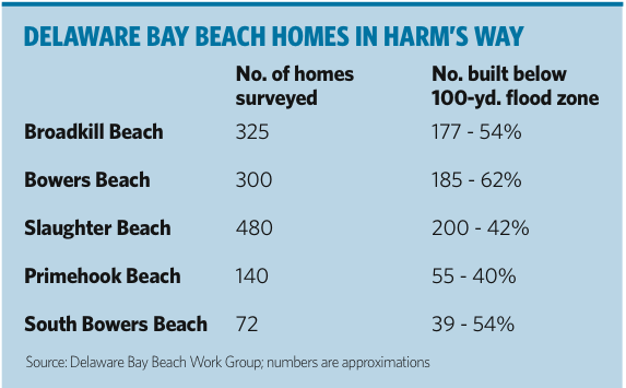
About half of all homes along the Delaware Bay are built below the established 100-year-flood height levels as established by FEMA. Flood heights are established using models backed up by historical data, including events such as the Storm of '62; high levels range from 13 feet to 8 feet along the bay coast. The numbers reflect storm surge and wave height.
FEMA has redrawn the coastal zone flood maps at least five times since the 1970s, said Mike Powell with DNREC's Flood Mitigation Program. Federal officials are in the process of updating flood-plain data again. “The trend has been upwards,” he said.
Construction standards require all homes in the flood zone be built no lower than the established flood-zone height. In an area with a 10-foot flood zone, new homes must be built with the first floor of living space at least 10 feet off the ground using pilings and columns. Homes along the marsh area can sometimes build with concrete foundations that provide a crawl space that allows for the free flow of water.
Powell said some homeowners have taken steps to secure their older coastal homes, but it can be costly. Adding a higher foundation can cost from $25,000 to $30,000 and lifting and placing a home on pilings can cost from $100,000 to $150,000.
A survey of DNREC data show that nearly half of the homes in Primehook are built an average of 3 feet below the 9- or 10-foot-flood level. In Broadkill Beach, more than 200 of the nearly 500 homes surveyed are built an average of 3 feet below the 9- to 11-foot-flood zone. Many of those homes are on South and North Carolina avenues, North and South Bayshore Drive and West Virginia Avenue.
Of the 300 homes surveyed in Slaughter Beach, more than half are built an average of 3.5 feet below the 8- to 10-foot-flood zone, with several along Bay Avenue built 6 or more feet below flood level.
In South Bowers, more than half of the 72 homes surveyed are built an average of 4 feet below the 10-to 11-foot-flood level.. In addition, more than half of the 325 homes surveyed in Bowers Beach are built an average of 3 to 4 feet below the 9- to 11-foot-flood zone.
Through DNREC's sea-level rise initiative, a model project is under way in Bowers Beach to help the town reduce coastal hazard vulnerability due to sea-level rise. Bowers Beach currently experiences a number of coastal related problems including nuisance flooding of streets, episodic storm damage, and coastal erosion.
The plan will address current and future risks associated with climate change, including the potential effects of sea-level rise, increased storm frequencies and intensities, increased rates of erosion, saltwater intrusion, wetland loss and other impacts.
Next week: What is a 100-year storm and why is the term important?