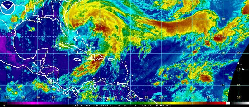
Hurricane Sandy continued north Friday hanging off the coast of Florida and gaining strength, according to weather experts.
The previously category 2 Hurricane has been downgraded to a category 1 as it moves north at 6 mph with winds ranging from 80 to 130 mph. The storm's speed has slowed from the 18 mph it was moving yesterday; however, the slower speed is allowing the storm to pick up intensity as it spreads over a larger area, meteorologists say.
Weather experts predict the storm will continue north through Saturday and Sunday and are leaning toward a European weather model for landfall in the Mid-Atlantic. That model shows the storm center moving northeast Monday afternoon to Tuesday morning and powering over the Delmarva peninsula, experts say.
A U.S. storm model serves as a second scenario in which the storm center hits the New England coast. Regardless of where the storm hits, forecasters say a dip in the arctic jet-stream could add snow to the spiraling storm prompting some to dub it "Frankenstorm."
The Weather Channel predicts rain will begin Saturday and continue for several days.
A full moon on Oct. 29 with corresponding high tide set for 7:24 a.m. Monday may intensify the flow of water up the Delaware River, said Mitchell Gaines, meteorologist with the National Weather Service in Mount Holly, N.J.
"The combination of storm surge, high tides and full moon could potentially pull water up the Delaware River," he said.
Coastal flooding, heavy wave action and beach erosion are possibilities if Sandy hits the region, Gaines said.
But the storm is not bad news for everyone.
State Agriculture Secretary Ed Kee said farmers will welcome the additional rainfall because precipitation is down about 14 inches for the year. According to Accuweather statistics, precipitation in 2011 ended 8 inches below the annual 44-inch average.
"Streams are the lowest I've seen them in 40 years. There are ditches and farm ponds that are lower than they've ever been, or they're totally dried," Kee said. "We need a nice soaking rain, but we don't need the wind to blow the crops over."
Sandy's impact on the Mid-Atlantic coast could run into billions of dollars, said Jeff Masters, meteorologist with Weather Underground.
"Sandy would be able to bring sustained winds near hurricane force over a wide stretch of heavily populated coast, causing massive power outages, as trees still in leaf fall and take out power lines," he said. "The full moon is on Monday, which means astronomical tides will be at their peak for the month, increasing potential storm surge flooding."
Melissa Steele is a staff writer covering the state Legislature, government and police. Her newspaper career spans more than 30 years and includes working for the Delaware State News, Burlington County Times, The News Journal, Dover Post and Milford Beacon before coming to the Cape Gazette in 2012. Her work has received numerous awards, most notably a Pulitzer Prize-adjudicated investigative piece, and a runner-up for the MDDC James S. Keat Freedom of Information Award.


