Some thoughts and concerns about the proposed subdivision known as Point Farm just off of New Road, in the area of Canary Creek. I have been a member of the community group known as CALL for a number of years and have worked with my neighbors to preserve and protect a great deal of land on the outskirts of the town of Lewes.
During the many years of struggles over the protection of much of this land, I have repeatedly brought up the untenable problem of flooding that we must put up with on New Road as a result of the high water in the area of the Canary Creek Bridge on New Road.
You will recall New Road is one of the major evacuation routes for the town of Lewes. It is my understanding, and it should also be noted that the Canary Creek Bridge, as originally constructed, was built 1.5 feet below mean sea level. This is a major reason why New Road floods at that point and becomes impassible during significant (3-plus inches) rain storms.
I also would like to point out that I, along with several other FCC licensed amateur radio operators, as well as the sponsorship from the City of Lewes, have helped organize an emergency radio organization (Radio Amateur Communication Emergency Service - RACES) as a special emergency communications resource for the Greater Lewes Community in times of disasters.
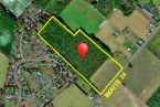
My experience and concerns with disasters is one of the reasons why I am writing today to ask that you consider very carefully the steps you are about to take in considering the review of a subdivision plan for The Point Farm project on land directly behind my home and adjoining the wetlands of The Great Marsh and near the bottom of the Canary Creek.
Some of my neighbors have lived in their homes on New Road since 1962 when a powerful winter storm stalled off the coast of Lewes and resulted in major flooding in the town and along New Road in the area of the Canary Creek Bridge.
According to the information I have been able to obtain, the headwaters of Canary Creek begin just on the other side of the Route 1 (near where the Wawa is located near the State Police Station). If you will imagine with me how much development has occurred along that stream corridor between Route 1 and the bottom of the creek behind my home, since 1962, you will understand my concern about this project. which is most likely to contribute additional storm water into the Canary Creek. Unlike some projects one to two miles away the water runoff from this development will be filling the bottom of the barrel first, and all the other runoffs will be trying to get into the Canary Creek bucket further upstream, later on.
I am fearful that this will add substantially to this terrible situation we have already had to put up with for many years. There is a great likelihood that this project will cause new and additional flooding more frequently and faster than in the past, because there is nowhere else for the water to go. The geography of this area is a significant factor when you have the northeast storms that holds the water into the Lewes-Rehoboth Canal and prevents both the Broadkill River and Canary Creek from discharging into the lower bay off Roosevelt inlet. If I am not mistaken I believe in the 2005 Comprehensive Plan the city suggested that in order to minimize the impact of future flooding, and to protect the all-important wetlands around Lewes some needed protection areas and buffers of those fragile wetlands surrounding the edges of Lewes were needed.
There was a recommendation for some mandatory setback requirements on building close to wetlands, but that proposal has not been adopted as of this date. Also I believe there was similar work done by Lewes Hazards Mitigation study group, in conjunction with the UD, that concluded in a report in 2011 with some of the same ideas, this report also called for the establishment of a protective buffer for wetlands in the Lewes City Code, and recommended that no new construction should be built in the flood plain. If my data is correct a great deal of this property is within the flood plain .To the best of my knowledge neither of these proposal have been implemented yet.
It would seem to me that before the Lewes Planning Commission responds to the request of a developer for more construction in the environmentally sensitive area next to the Great Marsh that you folks should put some of your energy first into better protection of Lewes area residents by studying and adopting a new stronger standard to protect the vital wetlands called for in the 2005 Comprehensive Plan and again in 2011 within the Hazard Mitigation plan, then after you have completed your work on behalf of the Lewes residents then you might take up your remaining extra time working on the proposed subdivision for the development interests that are putting added strains and pressure on the entire town of Lewes.
I hope will give you great pause about building any further homes along the bottom of the Canary Creek watershed.
Thank you for your time and attention and consideration of my suggestions.
Richard Drevo
Lewes
-

A letter to the editor expresses a reader's opinion and, as such, is not reflective of the editorial opinions of this newspaper.
To submit a letter to the editor for publishing, send an email to viewpoints@capegazette.com. All letters are considered at the discretion of the newsroom and published as space allows. Due to the large volume of submissions, we cannot acknowledge receipt of each submission. Letters must include a phone number and address for verification. Keep letters to 400 words or fewer. We reserve the right to edit for content or length. Letters should be responsive to issues addressed in the Cape Gazette rather than content from other publications or media. Letters should focus on local issues, not national topics or personalities. Only one letter per author will be published every 30 days regarding a particular topic. Authors may submit a second letter within that time period if it pertains to a different issue. Letters may not be critical of personalities or specific businesses. Criticism of public figures is permissible. Endorsement letters for political candidates are no longer accepted. Letters must be the author’s original work, and may not be generated by artificial intelligence tools. Templates, form letters and letters containing language similar to other submissions will not be published.