Rehoboth Bay and sparsely populated Dewey Beach in the 1930s

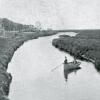
This picture postcard shows the head of Rehoboth Bay, in its northeastern corner, and the sandy streets of what was barely even known as Dewey Beach in the 1930s. Postmarked from Rehoboth Beach in 1938, the romanticized aerial view capitalizes on Dewey’s unique setting between Atlantic Ocean and Rehoboth Bay and its protected Head of Bay Cove, which has long been a haven for sailing and other water sports.
Rehoboth Bay is the northernmost of Delaware’s Inland Bays, encompasses about 13 square miles, and averages little more than six feet in depth. Though the bay is generally salty because of daily tidal exchanges with the Atlantic Ocean via Indian River Inlet, a number of creeks feed fresh water into the system including White Oak Creek, Love Creek, Herring Creek and Guinea Creek.