Sussex P&Z questions Twin Masts plan

Traffic concerns and proximity to a private airport were front and center during a presentation on a proposed subdivision along Round Pole Bridge Road near Milton.
Many residents questioned how the curvy, narrow road with a current daily traffic count of 290 vehicles would be able to handle an estimated traffic count of 2,000 vehicles.
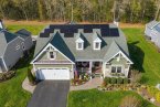
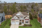
At its March 9 meeting, the Sussex County Planning & Zoning Commission heard plans for Twin Masts, a 249-single-family home cluster subdivision on a 133-acre parcel, which is adjacent to Route 1 and Hudson Fields and Eagle Crest Aerodrome.
During a discussion after the hearing, commissioners expressed concerns with the proposed site plan, and went so far as to say another updated plan may be required.
“It's not done. They are attempting to fix a bicycle while riding it,” said Chair Bob Wheatley. “This is still being negotiated. It's moving too fast. I'm more interested in doing it right even if we have to do it again. They have not addressed superior design and the terrible road.”
Commissioner Holly Wingate emphasized that the developer's representatives had only met with residents two days prior to the hearing.
Wheatley said he was impressed by some of the opposition's testimony. “There was a lot of ordinance-based testimony,” he said. “I have concerns about the superior design aspect.”
The commission voted to keep the public record open to obtain more information from Delaware Department of Transportation officials on two questions: Is an entrance on Route 1 possible, and what would it take to make it possible? What is the acceptable level of service on Round Pole Bridge Road?
Once the information is received from DelDOT and announced during a meeting, the public and applicant will have 15 days to respond in writing.
About the property
The parcel, which is located adjacent to Beaver Dam Creek and near the Broadkill River, contains 8.3 acres of tidal and 4.6 acres of nontidal wetlands. Plans include 50-foot buffers along tidal wetlands and 25-foot buffers along nontidal wetlands, which are not required.
The developer’s attorney, Mackenzie Peet, said the parcel is located in a low-density area where the county comprehensive plan promotes single-family developments.
Of the 68 acres of open space, 51 acres would be contiguous, said Jim Eriksen, engineer with Solutions IPEM. He noted there are sections of flood plains on the parcel, and development on those sections would be limited.
He said the open space aligns with the airport runway, and lots are at least 1,931 feet from the runway.
A 4-foot earthen berm with vegetation is planned along the southern lanes of Route 1.
Environmental consultant Ed Launay said there are six old borrow pits on the parcel used during the construction of Route 1, which are not considered wetlands. The parcel contains 79 acres of farmland and 44 acres of upland forests adjacent to wetlands. Plans call for removal of 59% of the woods, with trees retained in the most environmentally sensitive areas.
The community would have a pool, bathhouse and sidewalks on both sides of all interior streets.
In the flight path
Peet said the development team has met with nearby residents and pilots who use Eagle Crest Aerodrome. Pilots taking off would pass over the subdivision.
She noted that Federal Aviation Administration regulations do not apply to private airports, but the developer would relocate several lots on the flight path to create more open space near the airport.
She said a notice in the HOA regulations would state that noise would be generated by planes using the airport.
“It’s been determined there is no hazard to air navigation,” she said.
John Chirtea, a pilot who lives on Eagle Crest Road and is president of the community’s HOA, said he’s convinced an agreement can be reached to get a clear flight path.
Jeff King, an Eagle Crest pilot, said taking safety precautions for the airport is something that should not be rushed through.
“There is a determination of no hazard by the FAA. What does this mean when it doesn’t apply to private airports?” he asked.
Issues with roadway
Access to the property would be from Round Pole Bridge Road. Eriksen said the developer would improve the road from the parcel’s frontage to Hudson Road with 11-foot travel lanes and 5-foot shoulders.
Several DelDOT projects are either underway or planned in the area, including the Route 16-Route 1 grade-separated interchange under construction, and the proposed elimination of Route 1 median crossovers at the Hudson Road and Eagles Crest Road intersections. He said road crossovers and left turns onto Route 1 would be eliminated.
Construction of the Cave Neck Road-Route 1 grade-separated interchange is scheduled to begin in 2025, and improvements, including a roundabout, at the intersection of Hudson-Sweetbriar-Cave Neck roads will begin in 2024.
He said the developer would be responsible to contribute funding to all of the projects.
Eriksen said once all of the road improvement projects are completed, traffic patterns will change.
Following the hearing, Eriksen said the developer would redesign the entrance to prohibit right turns from the development, as well as left turns from Round Pole Bridge Road, forcing motorists to use Hudson Road to reduce the number of trips.
Commissioner Kim Hoey Stevenson said traffic generated by the proposed subdivision is a big deal. The average daily traffic count would increase from the current 290 trips to more than 2,000 trips at build out of the community.
“Round Pole Bridge Road is just a little bit better than a dirt road. What can be done to make the road better or be designed not using it?” she asked.
Hoey Stevenson asked if an access road to Route 1 would be possible.
Eriksen said the traffic-impact study noted that motorists would use Hudson Road rather than Round Pole Bridge Road.
“More than 2,000 trips up and down Round Pole Bridge Road is my concern. It’s not a road built for that kind of traffic,” Hoey Stevenson said.
Eriksen said it would be faster to use Hudson Road. “Have you done that in the summer?” asked Hoey Stevenson.
“Traffic patterns will change with the elimination of the crossovers,” Eriksen added.
Residents express concerns
Several residents pointed out that the commission had denied an application for a 25-lot subdivision on Round Pole Bridge Road, which was appealed and upheld by Sussex County Council.
Sara Esposito, an environmental engineer who works for DelDOT, said she was testifying as a resident and not a DelDOT representative.
She had a long list of concerns, including 50 proposed lots in flood plain areas and the condition of Round Pole Bridge Road, which she said is an 18-foot, tar-and-chip roadway with crumbling edges and no shoulders.
She said DelDOT regulations require that roads with 500 average daily trips be constructed of hot mix, which the road would have to be if the project is approved.
She said the cost of new tar and chip for the road would be $100,000 compared to more than $1 million for hot mix.
She questioned why the Cave Neck Road-Round Pole Bridge Road intersection was not included in the traffic-impact study when people use the road to go to Milton for shopping, schools and medical offices.
Heather Kingree, who grew up on Round Pole Bridge Road and whose mother still lives there, said the developer did not follow the code by not marking out and protecting environmentally sensitive areas. She said the developable area of the parcel is 79 acres away from wetlands and woods, which would allow for 98 lots, not the 249 that are proposed.
She said the parcel contains mature forests, flood plains and a water recharge area.
“The intent is to minimize impact on environmental areas. That gets lost and projects get pushed through,” she said.
The recharge area should be left intact, yet it would be clear-cut for lots, she said.
In addition, she said, interconnected open space at the back of lots should not be counted.
Milton resident Jeff Seemans said the proposed preliminary plan is an imposter pretending to be a superior design subdivision.
He said 60% of the woods would be removed, 30 lots would be built in flood plains, there are no landscape views except for two lots and 107 lots back up to stormwater ponds. “This is not superior design,” he said.
“Avoiding lots in flood plains is standard practice all over the county,” he added. “You are allowing the zoning code to be perverted. The plan disregards the natural environment. It should be denied and reworked to adhere to the cluster ordinance.”
Al Rizzo, who lives on Deep Branch Road, said one-third of the parcel is located on an excellent recharge area. “Roads and houses will cover the best recharge area in the area," he said.
He questioned how the project could be considered superior design because of removal of 60% of forests and displacement of wildlife. “What constitutes superior?” he asked.
Christian Hudson, owner of Eagle Crest Aerodrome, said he doesn’t oppose the land use, but he does question the site plan.
He said the conditions should include a notice of HOA pre-existing restrictions relating to Hudson Fields to preserve the property rights of the airport and entertainment venue.
In addition, he said, the commission needs to make sure lots are removed in the flight path.
The public record contains a petition signed by 212 residents who are opposed to the application.
Wheatley said the superior design standards are being questioned by residents. “What are the superior design elements of your plan?” he asked the developer.
Eriksen said the elements include significant open space, buffers well beyond minimum requirements to protect environmentally sensitive areas and wetlands, and several amenities.
For more information about the application, go to connect.sussexcountyde.gov/OnBaseAgendaOnline/Meetings/ViewMeeting?id=131&&doctype=1.