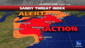
Tide, wind could be challenge for Cape Region
Tide and wind conditions could combine to create extreme tidal surge in coastal Sussex county's low-lying areas.
“Because of the slow-moving aspect of the storm and a full moon, water is going to be pushed in. We might go through five or six tide cycles before the wind shifts to the northwest and water is pushed out,” Lewes Mayor Jim Ford said Oct.26.
He said the city might ask residents in low-lying areas to voluntarily evacuate if a predicted 8-foot tidal surge occurs.
Ford said flood-prone areas are Savannah Road east of the drawbridge, a section of New Road near Canary Creek, and the area around Cedar and Nebraska avenues.
He said if Cedar is flooded in that area, the evacuation route is through Childrens Beach House parking lot. “People need to use good, sound judgment,” Ford said.
He said Lewes experienced an 8-foot tidal surge on Mother’s Day in 2008; the 1962 storm caused a surge of 9.5 feet, he said.
He said the city, Board of Public Works and Lewes Fire Department had prepared as much as they could.
“We’ve gassed up all the vehicles and checked our generators. BPW personnel is on standby. If they need to respond they’ve been told to take care of their family and home first,” Ford said.
He said area municipalities have had periodic conference calls with Sussex Emergency Operations Center to get updated storm information. He said area fire departments were having separate conference calls with the center.
Scott Green, executive director of the Delaware River & Bay Authority, operator of the Cape May-Lewes Ferry, said anything that could be blown around has been secured. He said a decision is pending about moving ferries from Lewes to safer ports in Salem or Gloucester City, N.J.
“It’s an interesting ballet we have to do. We can’t just show up,” he said about docking vessels in New Jersey.
The ferry was running on its normal schedule at press time.
The National Weather Service is telling area residents to be prepared. Folks should:
• Clean up leaves! There a lot of leaves on the ground. Leaves are excellent material to clog/block storm drains, worsening local/neighborhood flooding. Get leaves and any other obstructing materials away from storm drains before this storm arrives.
• Engage in preparedness activities. Review your Family Emergency Plan and update as needed.
• Be prepared to evacuate if local officials instruct you to do so.
• Be prepared for potential long-term power outages.
• Secure outside items or bring them inside as it appears increasingly likely we will see very strong wind gusts.
Sussex County produced its first YouTube video update about the storm (see video embedded upper left) at its Emergency Operations Center. Follow Sussex EOC on Twitter for updates @SussexCtyDE_EOC or go to http://www.sussexcountyde.gov/dept/eoc/ for updates.


