State agrees to Milton’s proposed future land-use map
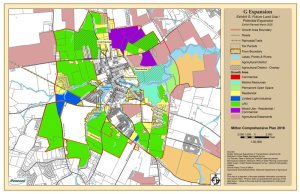
Milton Town Council is set to vote on a future land-use map that includes three parcels the town and state planning officials were previously at odds over, paving the way for the parcels to be included in the map and to include the parcels within the town’s transportation improvement district.
The updated map will be voted on by council at its regular meeting at 6:30 p.m., Monday, Dec. 1, at Milton library.
The future land-use map is important as it serves as a guide for Milton and how the town could be expanded via annexation. The map the town fought for extends the potential future borders of Milton as far north as Reynolds Pond Road, as far south as Neptune Road and east up to Beaverdam Creek. The town is required, as part of its comprehensive development plan, which is reviewed and ratified by the state, to submit a future land-use or expansion map.
Milton submitted its map as part of the 2023 update to its comp plan. However, state agencies voiced concerns about eight parcels they wanted to see removed from the map. That number was later reduced to three after discussions with town officials. The three properties state planners wanted removed are: Four Winds Farm, a development under construction on Shingle Point Road; Triple C Farms off Harbeson Road; and the property next to Triple C Farms. Town Manager Kristy Rogers has said the owners of the properties have all asked to be included in the future land-use map.
The objections mainly came from the Delaware Department of Transportation regarding the town’s transportation improvement district. Projects within a TID get priority for state funding, and DelDOT and Milton officials have worked on the TID for years. The argument from DelDOT is that if all the parcels are included on the future land-use map, it would mean the TID would have to be reconfigured to include all of them.
In addition, the state did not want the three parcels included because all three are rural farmland the state wants to protect.
However, town officials took the position that including the parcels protected the town’s interests, whether they are annexed into Milton or not. To clear the air, Dorothy Morris, the Office of State Planning's Sussex County liaison, and Dave Edgell, state planning director, attended council’s July 7 meeting, where the two sides heard each other out.
In September, the matter went to the state Cabinet Committee on State Planning Issues, which includes representatives from all state departments and the governor’s office. The committee decided to accept the town’s proposed map, including the three parcels, on the condition that town council hold a vote to approve what the state considers an amended map.
Mayor John Collier said he’s satisfied the state agreed to the town’s proposed map.
Ryan Mavity covers Milton and the court system. He is married to Rachel Swick Mavity and has two kids, Alex and Jane. Ryan started with the Cape Gazette all the way back in February 2007, previously covering the City of Rehoboth Beach. A native of Easton, Md. and graduate of Towson University, Ryan enjoys watching the Baltimore Ravens, Washington Capitals and Baltimore Orioles in his spare time.


.jpg)


