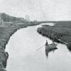
Bird’s-eye view of early 20th century Lewes

This is most likely the second-earliest bird’s-eye view of Lewes ever made, according to the book Lewes to Laurel in Vintage Postcards from the Delaware Collection at the Lewes Public Library.
Without the Lewes Presbyterian Church cemetery, Kings Highway and the steeple of St. Peter’s Episcopal Church visible, the First Town would be nearly unrecognizable in this undated photograph.
Since the Zwaanendael Museum doesn’t appear to be standing at the corner of Kings Highway and Savannah Road, this photograph was likely made before 1931. At the time, Kings Highway was known as King Street, and it is seen here running behind the cemetery and curving to Savannah Road, called South Street at the time.
Other notable observations include the smattering of homes on Lewes Beach and the nonexistence of E. Third Street, where Lewes City Hall is located today. The street closest to the camera, running left to right, is Franklin Avenue, which today leads back to the Schley Avenue parking lot, and the city and BPW facilities.