Seashore State Park history tied to IR Inlet and its jetties

In the early 1900s, when Indian River’s inlet changed locations almost as often as the weather changes, farmers and fishermen looked to the state for help. But if the state didn’t move quickly enough, they took matters into their own hands.
When storms filled the oft-shifting inlet with sand, Indian River and Rehoboth Bay’s waters backed up, leading to flooding of surrounding farmland. That damaged the tomato and hay crops on which the farmers depended, both for cash and feed for their livestock.
For fishermen, a closed inlet meant fewer species to catch in the bays. It also changed salinity in the bays, to the detriment of clams and oysters.
In August 1919, tired of waiting for the state to decide where to open a new inlet after the former one closed in a storm, local residents bought dynamite and opened the inlet themselves. They estimated the closed inlet had already caused several hundred thousand dollars’ worth of damage to their crops because of flooded farmland. They had had enough.
A newspaper clipping in Delaware’s Public Archives from September 1923 noted that the new inlet would “be adapted for the use of small boats only, but it will prevent overflowing of the surrounding farmlands and enable the raising of hay which is a profitable industry in that section.”
But the article also stated what most people were already feeling, after watching the inlet shifting constantly, opening and closing with storms, and costing frustrating amounts of money to reopen time and time again. “There is a general feeling in that section that any inlet, no matter where dug, connecting Indian River Bay and Atlantic Ocean, will shoal with sand unless a jetty is built out in the ocean to divert the current and shifting sands.”
However, the state appropriation that year was not enough to build the needed jetty.
The first jetties finally did come in 1938 as part of the effort to build the first real ocean highway along the barrier islands to connect Rehoboth Beach and Bethany Beach. According to a February 2020 article by Delaware Seashore State Park historical interpreter Kenneth Horowitz, the first highway was built in 1933, along with the first crossing of Indian River Inlet – a wooden bridge.
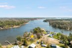
Without jetties, however, constant dredging to keep the inlet open and to protect the highway became cost-prohibitive. That’s when the U.S. Army Corps of Engineers stepped in and aided with construction of two steel-and-wooden jetties, one on each side of the inlet.
The state also removed the previous fixed wooden bridge and replaced it with a sturdier swing bridge which would accommodate shipping in and out of Indian River.
The stabilized inlet and new bridge created the beginnings of a small seasonal community of campers and fishermen at that location, which eventually grew into Delaware Seashore State Park. The park, with its six miles of ocean coast and 20 miles of bay shore lands – mostly marsh – first opened in 1965 as Indian River State Park. Then in 1967, the park – operated by the State Parks Commission – was renamed as Delaware Seashore State Park.
According to Shauna McVey in Delaware’s Division of Parks public relations department, a number of significant improvements are slated over the course of the next year, funded by the state’s 2021-22 bond bill and Community Redevelopment Fund. Here’s what McVey explained:
“The final phase of Tower 3 restoration in Delaware Seashore State Park will include interior steps and access to the roof. By next summer, visitors will be able to walk to the top of the tower and see the Atlantic Ocean and Inland Bays. This project also includes paving of the Tower 3 parking lot and improved drainage.”
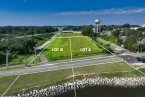
Tower 3 is a World War II concrete fire control tower built for spotting enemy ships and providing triangulation calculations for targeting the big guns at Fort Miles, where Cape Henlopen State Park is now located. The tower is located at the Tower Road section of Delaware Seashore State Park just south of the Indian Beach community.
McVey also said $400,000 was allocated to Fenwick Island State Park to assist with planning for a new parking lot, secondary egress, drainage work and new schematic layout of the park to improve services and lifeguard offices. That work will also help move the Bethany-Fenwick Area Chamber of Commerce building to within the park and improve the pedestrian crossing to the beach.
She said $200,000 was also received for planning of the final phase of the Assawoman Canal Trail south of Route 26. That trail parallels the Assawoman Canal between Whites Creek and Little Assawoman Bay, a distance of several miles. “The goal,” said McVey, “ is for the trail to be 2.5 miles long when completed. The southern terminus of the trail will link to Black Gum Drive in South Bethany. The completed section along the west bank from Route 26 to just south of the Ocean View Marina is 1 mile. The future trail section of 1.5 miles will be along the east bank of the canal from Route 26 to Black Gum Drive in South Bethany (just south of Kent Avenue).”
She added that appropriations were also included for an erosion issue at Bubblegum Beach near the Center for the Inland Bays headquarters along Indian River Inlet and noted that the Indian River Marina dry stack building will receive a new roof and potential siding, depending on the upcoming bid opening.
Since its humble beginnings in 1965, Delaware Seashore State Park has grown into its own 2,825-acre dynamic and popular recreational community centered around the historic inlet.
It hosts millions of visitors each year who come for its beaches, trails, inlet fishing, cottages, marina facilities, kayak and canoe touring, as well as dining at two seasonal restaurants.
-

Dennis Forney has been a journalist on the Delmarva Peninsula since 1972 and has been writing his Barefootin’ column for The Whale and then the Cape Gazette for more than 30 years. He blogs at www.capegazette.com/blogs/dennisforney. Contact Dennis at dennisforney@capegazette.com.