Sussex council looks at changing developing district

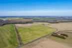
Sussex County Council could take action to provide a safeguard for environmentally sensitive lands that lie between Route 1, the Great Marsh and Delaware Bay.
Council is poised to change the designation of a long stretch of land east of Route 1 from a developing district to a low-density district in the 2018 comprehensive plan future land-use map.
Councilmen George Cole, R-Ocean View, and I.G. Burton, R-Lewes, suggested changing the designation of the area from Red Mill Pond near Lewes north to the Route 30 overpass near Milford and the new Bayhealth Hospital Sussex Campus.
Based on recommendations from Cole and Burton, who represent coastal Sussex, county staff will draw a revised land-use map for council’s consideration during its Tuesday, Nov. 13 meeting.
Assistant county attorney Vince Robertson reminded council that the plan's maps carry the force of law once the plan is certified.
“The land east of Route 1 should be protected any way we can because the area backs up to the Great Marsh,” Burton said.
Developing districts allow for higher density and for commercial projects.
Cole suggested all existing farmland east of Route 1 should be designated low density, which is AR-1 zoning. In addition, he said proposed changes to widen buffers could add more protection in the area.
Permitted uses in AR-1 zoning would still be allowed, but public hearings before planning and zoning and county council would be required for upzoning in the area. Since a rezoning is not by right, county officials have more authority to deny an application.
That's exactly what happened earlier this year. Cole said county council took a stand on development east of Route 1 when it unanimously denied a rezoning application near Milford.
On Feb. 27, council rejected the rezoning of a 17-acre parcel on the east side of Route 1 across the highway from the new Bayhealth campus.
Making the motion for denial, Burton said he was concerned about development along the Route 1 corridor between Milford and Milton and south to Lewes.
“This property is a keystone in how Sussex County treats future land-use applications and development east of Route 1,” Burton said during the meeting. “If we approve this one, it signals that Sussex County believes that more intensive uses are appropriate in this area.”
Burton said land on the east side of Route 1 should remain AR-1 – 2 units per acre by right – with the uses permitted under that zoning district.
Council rejects requested changes
Council acted on several other requests to change land designation on the future land-use map from low density to developing districts, rejecting all but one that they deferred to receive more information. Robertson said while the plan is for 10 years, council can vote to change land-use designation any time during the decade. “It's not set in stone,” he said.
The comprehensive land-use plan consultants had designated each of the parcels as low density, which includes AR-1 zoning.
Parcels denied included two in the area along Route 30 and Route 16 near Milton.
“There is no development need,” Cole said. “There is no need to change the map.”
“It can be changed in the future, but today I see no evidence to expand that type of zoning in that area,” Burton said.
“It's not a forever decision,” said Councilman Rob Arlett, R-Frankford. “We should take the advice of our consultants.”
Council also rejected a request to change from low density to developing district for multiple parcels bordered by Route 9, Hudson Road and Sweetbriar Road near Lewes.
“If we expand this district, it sends a bad message to the people of Sussex County about development. I don't see the need. There is limited sewer availability and large farm acreage,” Cole said. “At any time someone can come in and ask to have their land developed.”
Council may take another look at individual parcels in the tract at its Tuesday, Nov. 13 meeting.
Council deferred on a request to change a parcel to a developing district on the west side of Route 1 at the Route 16 intersection where a new overpass will be constructed, across the highway from The Rookery South Golf Club.
Cole said he has concerns with the request because it would imply promotion of commercial development in the area, and he's not sure what impact that would have. “I think we can wait down the road,” he said.
Burton disagreed. “It's west of Route 1, and we know the overpass is coming. That corner should be a developing district,” he said.
Robertson said he's not sure whether the consultants had information from state transportation officials on plans to build a grade-separated interchange at the intersection, which could have had an impact on the parcel's land-use designation. He said he could meet with consultants and report back to council at the Nov. 13 meeting.
Council's votes expected Nov. 13
At the Nov. 13 meeting, councilmembers are expected to vote on the future land-use map as well as the county's response to the Office of State Planning Coordination Preliminary Land-Use Service comments.
That response will include reaction to Delaware Housing Authority officials' comments stating the county's draft plan is prohibitive to medium- and high-density residential development in areas where there is an acute need for affordable and workforce housing.
“We are in discussions now so you can have a final vote,” said County Administrator Todd Lawson.
Once a vote is taken, the plan will be resubmitted to the state for final review.