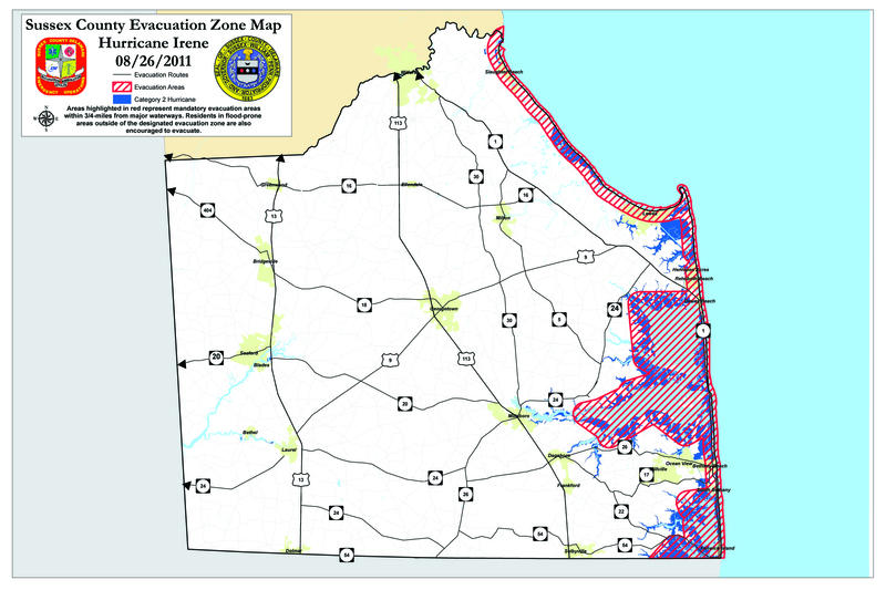
A mandatory evacuation for coastal communities within three-fourths of a mile of major waterways is in effect for the state of Delaware as Irene continues to threaten the East Coast.
Irene has weakened overnight, but forecasters say the storm is expected to remain a hurricane as it moves northward along the coast.
Mandatory evacuation began yesterday; residents are expected to vacate their homes by 9 a.m. Saturday.
Meanwhile, at 3:30 p.m. Friday, wind analysis from the National Oceanic and Atmospheric Administration estimated the potential storm surge damage from Irene at 5.0 on a scale of 0 to 6, meaning coastal areas could sustain serious damage.
Tides are at their highest levels of the month this weekend because the moon is at its closest approach to the earth. Forecasters say storm surge flooding can be expected to be at a maximum during the high tidal cycles that will occur at 8 p.m. Saturday night and 8 a.m. Sunday morning.
Major waterways affected by the tides include Delaware Bay, Atlantic Ocean, Rehoboth Bay, Indian River Bay, Little Assawoman Bay, and Pepper Creek.
In Sussex County, communities under evacuation orders include Fenwick Island, South Bethany, Bethany Beach, North Bethany, Dewey Beach, Rehoboth Beach, Lewes, Henlopen Acres, Broadkill Beach, Prime Hook Beach, Slaughter Beach, Long Neck and Oak Orchard.
Gov. Jack Markell also ordered private businesses to close Saturday and into Sunday until the order is lifted.
He advised people living along flood prone streams to take precautions, and Sussex County residents living in manufactured housing should consider relocating because of the potential high winds. However, officials said resources are not available to cite residents who choose to remain in their homes. People who do not evacuate stay at their own peril, said Catherine Rossi, spokeswoman for Markell.
"Today is the day to prepare for a few days of being in your home without being able to travel and without power and be ready to evacuate quickly with all that you need, should it come to that," Markell said. "If this hurricane occurs in Delaware as currently predicted, the damage will be unlike anything seen in this state for more than 50 years. Do not take this lightly. Today is the day to act."
Sussex County shelters will be available at Beacon Middle School, Indian River High School and Milford High School.
With anticipated wind gusts predicted to reach 100 mph, significant rain and a storm surge, Markell said it's likely the Indian River Bridge and bridges over the C&D canal in New Castle will be closed.
Tolls on Route 1 have been suspended to facilitate the evacuation, and Delaware state offices were closed at noon Friday.
A driving ban has not been issued, but Markell asked people to stay clear of the evacuation areas.
All Delaware State Police troopers are on call and 1,500 Delaware National Guard members will assist the Department of Transportation with its evacuation plan, Markell said.
Chesapeake Bay Bridge
As of 1 p.m. Friday, the Maryland Transportation Authority announced it has no immediate plans to close any facilities in advance of the storm – every effort will be made to keep its bridges and tunnels open as long as conditions are safe for travelers, including the Chesapeake Bay Bridge.
Maryland officials said motorists crossing the Bay Bridge and other bridges should take note that closures will occur when sustained winds reach 55 miles per hour.
Current forecasts indicate wind speeds could reach that point as early as Saturday afternoon. Anyone planning to travel from the Eastern Shore to the Western Shore to ride out the storm is encouraged to do so Friday night or no later than early tomorrow morning.
High tides problematic
High tides the next few days will have more impact as the moon approaches perigee, the monthly point when the moon is closest to the earth. Tides will increase in range and speed until the culminating perigee on Tuesday, Aug. 30.
According, to National Oceanic and Atmospheric Administration and Air Force Reserve Hurricane Hunter Aircraft, the intensity of Irene has decreased a bit, but remains a Category 2 hurricane and continues to move toward the Mid-Atlantic coast at 14 mph. It is expected to remain a large and dangerous tropical cyclone with potential to produce damaging winds, storm surge flooding and extremely heavy rains.
The Weather Underground website predicts the hurricane will hit the Delaware Coast at 8 a.m. Sunday as a Category 1 hurricane with winds 74-95 mph.
Melissa Steele is a staff writer covering the state Legislature, government and police. Her newspaper career spans more than 30 years and includes working for the Delaware State News, Burlington County Times, The News Journal, Dover Post and Milford Beacon before coming to the Cape Gazette in 2012. Her work has received numerous awards, most notably a Pulitzer Prize-adjudicated investigative piece, and a runner-up for the MDDC James S. Keat Freedom of Information Award.


