Change to Sussex land-use map mired in confusion

In a confusing series of events, the 2018 Sussex County comprehensive plan future land-use map has five parcels totaling 247 acres designated as a low-density area on the east side of Route 1 north of Lewes. In those districts, the type of permitted development is limited.
The primary owners of the parcels, the Robinson family and Seaside of Lewes LLC, say that designation was changed from a growth zone to a low-density district after public hearings on the plan had been concluded. They want Sussex County officials to return the parcels' designation to a growth zone, now known as a coastal area.
In growth areas, many more development options are available, including high-density housing and commercial.
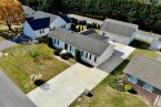
The property is the site of two approved phases of the Overbrook Meadows residential development. Phase 1 for 135 lots on 64 acres was approved in 2018, and Phase 2 for 82 lots on 43.5 acres was approved in 2019.
During a Nov. 18 public hearing, Sussex County Planning and Zoning commissioners heard arguments on both sides, including comments opposing the change by David Edgell, the new director of the Office of State Planning Coordination.
Sussex County Planning and Zoning Director Jamie Whitehouse said there are four letters in support and 51 letters in opposition to the request.
The planning and zoning commission deferred a decision to a future meeting. Sussex County Council has scheduled a public hearing on the request at its Tuesday, Dec. 14 meeting. Hearings get underway at 1:30 p.m.
A surprise to owners
David Hutt, an attorney representing the property owners, said his clients had monitored the comprehensive-plan process for 18 months and the future land-use map always showed the parcels in a growth area. “But that was not what was sent to the governor,” he said.
Once counties and municipalities develop comprehensive plans, they must be reviewed by state officials and certified by the governor.
Hutt said the owners discovered the change in late 2020 when the Chappell family was in the process of selling their parcels in the northern section of the property.
Hutt said there was a public hearing on the plan Oct. 23, 2018, with no discussion about the parcels. “The record was closed by county council and they deferred a vote,” the attorney said. “The next meeting on Oct. 30 was not a public hearing. This is the first time the designation of these properties came under discussion, and the designation was changed to low-density.”
Because the owners had requested an amendment to the map, it was reviewed by state agencies during the Preliminary Land Use Service process in June 2021. “Because the county was the applicant, the owners could not participate,” Hutt said. “It was like pouring salt in an open wound.”
State opposes map change
Edgell said state officials oppose the proposed change to the land-use map. He said state officials use a process to determine land designations – Levels 1 to 4 – based on analysis of 30 data layers concerning growth and preservation. Edgell said the property was considered Level 4 as a rural, farming area. Levels 1 and 2 are considered areas most suitable for development, and Level 3 is considered as an emerging growth area with infrastructure in place. Level 4 is considered least desirable for development due to environmental factors and the rural nature of the area.
He said the parcels are not in an urban area according to the U.S. Census, not near a town center or annexation area, not in a growth area, have no construction on them, are not on county sewer, and are not in proximity to bike paths, bus stops, trails, libraries, schools, state service centers, free-standing EMS services or police.
He said the parcels are near wetlands, in the Delaware Ecological Network and susceptible to sea-level rise.
Edgell said changing the parcels to a growth area would open up a large number of options for development, including high-density residential and heavy commercial.
“It's designated Level 4 not because we draw a line on a map or just because of the county's comprehensive plan, but because of a detailed analysis of all data layers,” he said, adding that state agencies have opposed other applications for projects on the parcel over the years.
He said if Sussex County Council votes to approve the land-use map change, the matter will be forwarded to the Cabinet Committee on State Planning Issues for further review.
Hutt: Wrong information
Hutt disputed several of the PLUS comments, including one that the parcels are not in close proximity to public utilities. Hutt said Tidewater Utilities has a 12-inch water line on the east side of Route 1 and Artesian Wastewater Management has an 8-inch sewer line on the west side.
He said state agencies were in error because they reviewed a larger parcel that included 415 acres that shared a border with wetlands. “That's wrong, and they don't have the full picture with that information,” he said, adding the section of wetlands mentioned in the PLUS comments is one-half mile to the east of his client's parcels.
Hutt said the parcels qualify under county code as a growth zone because of number of factors, including availability of water and sewer, proximity to a major roadway and nearness to other growth areas.
Wheatley: Process needs change
Commissioner Keller Hopkins said the perception the public had leaving meetings was that the parcels were in a growth zone. “What happened?” he asked. “Is there any shame on us for not notifying the property owners?”
Commission Chair Bob Wheatley said the process to amend the future land-use map has some issues at the county level. “It's our map, so technically we are the applicants and property owners are not involved. It seems to us they should be,” he said. “We have process issues, and we'll see what we can do about that.”
Jeff Stone of Milton, speaking on behalf of Sussex Alliance for Responsible Growth, said citizens had seven days' notice of the hearing. “There has to be a better way to get information out,” he said.
Whitehouse said the hearing was advertised 30 days prior to the date, but because it was an ordinance, notices were not mailed to surrounding property owners as is the case with other land-use applications.
David Green of Lewes, a member of Delaware Coalition for Open Government, agreed with Stone that there wasn't sufficient notification. He said the parcels should have been posted with public hearing signs, and letters should have been sent to nearby property owners.
SARG: Don't amend map
Stone read a four-page statement supporting the group's stand that the amendment to the future land-use map should not be made.
Stone said county council has already gone on record in the past as a proponent of preserving land east of Route 1. “This develops a defined edge for protection of the Great Marsh,” he said.
Stone said the state designates properties north of Willow Creek Road on the east side of Route 1 as Investment Level 4 areas in its state strategies for spending, where the retention of rural landscapes, and preservation of open spaces and farmlands are promoted.
“That is a precise and correct description of the nature of this area,” he said. “Now, less than three years into a 10-year plan, the new owners are requesting to change that designation to coastal, which would allow much denser development and not limited to residential.”
Stone said according to the state planning office, between 2016 and 2020, more than 93 percent of residential units approved statewide in Level 4 areas were in Sussex County. “Isn't there something wrong with that picture?” he asked.
Stone said approval of the request would set a precedent as other owners of low-density lands would seek a different designation allowing more intense development. “Once one of these properties changes, especially one as ecologically critical as this one, all of the dominoes must fall. However, there is no right given to developers to change a land-use designation because it doesn't fit their business model,” Stone said.
He said hundreds of homes can be built on the property without changing land designation. In low-density areas, several zoning districts are permitted, including B-2 - business community, C-2 - medium commercial, M - marine, and I-1 - institutional. “While these options may not generate as much profit as the developers would like, it is not the county's responsibility to maximize their return,” he said.
Stone disputed the argument that the proposed grade-separated interchange at the Cave Neck Road-Route 1 intersection makes the area appropriate for high-density development. He said road improvements being done under the state's corridor capacity program are in response to safety concerns, increasing traffic volume and an increase in vehicle crash rates. “They are not being done for the purpose of encouraging new high-density development,” he said.
In fact, he said, with high-density and commercial development, more traffic would be generated, and it would simply overwhelm the tens of millions of dollars the state is investing in improvements.
“It is a simple choice,” he told the commission. “Take the old road and continue to lose the things that make Sussex County, Sussex, or choose a new path that enhances that which makes Sussex special,” Stone said.