Sussex council will vote on map change Jan. 4

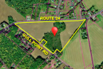
The Office of State Planning Coordination is taking a strong stand against a proposed Sussex County future land-use map amendment for five parcels totaling 247 acres of land on the east side of Route 1 at the Cave Neck Road intersection north of Lewes.
The property owners are seeking a change from the current low-density designation in the 2018 comprehensive plan to a coastal-area designation, which is considered a growth zone.
The owners' attorney, David Hutt, said the state's review of the proposal contains several inaccuracies, including an evaluation of 168 additional acres not included in the proposed amendment.
The primary owners of the parcels, the Robinson family and Seaside of Lewes LLC, say the map designation was changed from a growth zone to a low-density district after public hearings on the comprehensive plan, which includes the future land-use map, had been concluded.
They want Sussex County officials to return the parcels' designation to a growth zone (coastal area), which it had been since 2008.
In growth areas, many more development options are available, including high-density housing and commercial.
David Edgell, director of the Office of State Planning Coordination, said if county council approves the map amendment, the matter must be tabled and referred to the Cabinet Committee on State Planning Issues. If no agreement is reached, Gov. John Carney, who certifies all comprehensive plans, would give direction for a course of action. He said the cabinet council endorsed the planning office's opposition to the amendment.
“The coastal area allows considerable density not permitted in low-density. Up to 12 units [per acre] is what concerns us with 3,000 units possible. There could be quite a large development at that location. There has to be an area where development stops and agriculture begins,” Edgell said.
After the Dec. 14 public hearing, county council voted to defer a decision to the Tuesday, Jan. 4 meeting. Council also approved District 3 Councilman Mark Schaeffer's motion to keep the public record open to garner advice from assistant county attorney Vince Robertson and input from county staff on navigating through the amendment process in a correct manner.
Designation is changed
Hutt said his clients had monitored the comprehensive-plan process for 18 months, and the future land-use map always showed the parcels in a growth area. “But that was not what was sent to the governor,” he said.
Once counties and municipalities develop comprehensive plans, they must be reviewed by state officials and certified by the governor.
The map with the land designated as coastal area was recommended by the planning and zoning commission.
District 3 Councilman Mark Schaeffer asked how the map changed without public input.
Hutt said a council member – whom he did not name – requested the change to a low-density designation for several properties along Route 1. Hutt said between Oct. 30 and Dec. 4, 2018, planning and zoning staff redrew the maps, and council approved the changes.
“County council removed it in an arbitrary manner after the public process concluded,” Hutt said.
Hutt said during the final public hearing on the plan and map on Oct. 23, there was no mention of his clients’ property.
Hutt said when his clients realized the property had been changed, they filed a request to amend the map with the county. Because the comprehensive plan is certified by the state and governor, any amendments must be reviewed under the Preliminary Land Use Service process. Hutt said because the county was considered the applicant and not his clients, he was not permitted to speak during the PLUS meeting. “It was pouring salt on the wounds,” Hutt said.
In addition, he noted, state agencies reviewed a parcel that included much more land. “The property was misidentified. They did not have the full picture,” Hutt said.
Errors in state report
Hutt discussed nine factual errors in the PLUS report, including the incorrect acreage of the parcel, an incorrect statement that public water and sewer service is not available, and an incorrect statement regarding the property's proximity to wetlands. Hutt said the nearest tidal wetland is 675 feet away, with the vast majority of wetlands located one-half mile east of the property.
Schaeffer said the PLUS comments indicated there was no central water or sewer available to the property, but the applicant's attorney showed maps indicating the availability of both services for connection to the property.
“We were not able to obtain private sewer information from Artesian or Tidewater. We were told it didn't exist,” Edgell said.
State opposes amendment
Among several factors Edgell outlined as reasons to deny the amendment was the major impact it might have on the planned grade-separated interchange at Route 1 and Cave Neck Road. He said if the land is changed to coastal area, it could jeopardize the success of the road project.
Edgell said the design of the interchange is based on the county comprehensive plan's low-density designation of land east of Route 1. Edgell said the interchange – estimated to cost around $73 million – is not being built to allow greater density and large-scale development at the intersection. He said the reason behind the project is to improve safety, reduce congestion and improve access.
The project is scheduled to get underway in 2025 with rights-of-way purchases starting in 2022.
Councilman Schaeffer said he was under the impression that proximity to an arterial roadway was among the criteria used when determining a growth area.
Edgell said that is only one of several factors considered when proposals are reviewed by state agencies.
He said traffic data from the approved Overbrook housing developments with 250-270 lots at the intersection was used to design the project.
The property is the site of two approved phases of the Overbrook Meadows residential development. Phase 1 for 135 lots on 64 acres was approved in 2018, and Phase 2 for 82 lots on 43.5 acres was approved in 2019.
Hutt said an email he received from Delaware Department of Transportation officials stated the project was designed on 217 single-family home lots and 30,000 square feet of commercial space. “They assumed commercial development would be on that side of the highway,” the attorney said.
Hutt said a similar property at the intersection of Route 16 and Route 1 was changed to a growth area on the future land-use map with the planned grade-separated interchange at that intersection as one of the factors for the designation.
“The property is similar to the Route 16-Route 1 property, but it's even more appropriate because it's always been in a growth area,” he said.
SARG takes a stand
Jeff Stone, representing the Sussex Alliance for Responsible Growth, read a six-page letter opposing the land-use map amendment. He said the proposal brings into question whether or not the comprehensive plan is a true guide for the long-range development of the county. “This proposed change will have profound ramifications for Sussex County far beyond the parcels involved,” Stone said. “The comp plan is not even three years old, and there is no evidence showing that the decision by county council to designate these lands low density was incorrect, except that such a designation does not provide the owners and developer with a high-enough profit margin.”
Stone provided a list of the permitted zoning districts in the two areas:
Low-density lands: AR-1, agricultural-residential; B-2, business community; C-2, medium commercial; M, marine district; and I-1 institutional district.
Coastal areas: AR-1; B-2; C-2; M; I-1; MR, medium-density residential; GR, general residential; HR-1 and HR-2, high-density residential; B-3, business district; C-3, heavy commercial; C-4, planned commercial; and C-5, service and limited manufacturing district.
Stone said the low-density designation does not prohibit many types of development including construction of nearly 500 single-family homes and commercial construction such as hotels, retail stores, convenience stores, offices, long-term care facilities, educational institutions and surgical centers. In fact, he said, there are 116 commercial uses allowed. “Clearly, the developers have a wide array of options available to them that will allow significant return. Why do they need high density?” he asked.
“The new comp plan gives the county the opportunity to change course from the overdevelopment patterns of the last 10 years to a balance between rational growth that serves the community and the preservation of the quality of life, history and environment of Sussex County,” Stone said.
Other public comments
Jack Bucchioni, a resident of Paynter's Mill, who said he will be less than 50 feet from one of the proposed roundabouts of the grade-separated interchange, said he is not sure why a change is being requested. “What are the specifics? Where is the clarity? What is the plan?” he asked. “It's moving too fast. You did a great job on the comprehensive plan, and I hope you stick to it.”
Jill Compello, a Dewey Beach resident, said the council must act to protect the rights of the Robinson family. She said it was not a land-use application, but a request to restore the previous land designation. In addition, she said, restoring the designation does not mean automatic development, because any land-use applications for the property will have public hearings before council and the planning and zoning commission.
Compello also said the state's comments were based on incorrect information, including the assumption that water and sewer service was not available to the property, and that future development in the area was not considered by DelDOT.