Showfield sitework upsets neighbors
")


Attachments
A dense grove of trees along Gills Neck Road has been bulldozed, sparking sharp responses from some Lewes residents.
The trees were removed by the developer of the new Showfield subdivision to make way for a stormwater management pond, lot grading and road improvements that will soften an S-curve on Gills Neck Road.
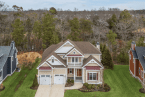
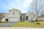
Representatives of Showfield, a new community just outside Lewes city limits, say most of the remaining old-growth trees on the 132-acre parcel will be preserved, and more mature trees will be planted when the community is landscaped. A 10-acre forest on the east side of the property will remain and will eventually feature a trail.
Doug Motley, representing Jack Lingo Asset Management, said developers prefer not to cut down trees because homeowners prefer wooded lots. But in this case, he said, the trees could not be saved. “We removed a minimum amount of trees to allow for the site to drain and function properly,” he said.
Motley said the cleared trees were 20 to 30 years old and had no value as timber. “The area was a farm field before,” he said.
Residents upset about the removal of the trees point to a conceptual Showfield plan presented to the county's planning and zoning commission that showed trees remaining along the curve.
Echoing their concerns, Jay Tomlinson of nearby Senators, said the planning and zoning commission minutes state that as many trees as possible would be retained. He called the removal of the trees an assault.
“How and who let this happen? Did the developer just do this alone?” he asked. “Having lived in the area just three years, I remain amazed that these types of things just seem to happen or not happen. The fact that this could happen on a scenic byway on a portion of the byway that is actually important to the character of the overall byway and Lewes leaves me completely astounded.”
Motley said the preliminary plan presented to the county's planning and zoning commission was modified based on final design work for roadwork and stormwater management. “Once preliminary approval is received, the construction documents are designed and submitted to each agency for review, changes, and ultimately final record plan approval. We must construct the project based on the final record plan that was reviewed and approved by the relevant governmental agencies,” he said.
Motley said the trees are being removed to make way for road improvements, which include clearing for the community's entrance and softening a curve on Gills Neck Road. When complete, the curve will be similar to another curve on Gills Neck Road near Cadbury.
Mark Cote, a Delaware Department of Transportation engineer, said to make the curve safer, a 15-foot section of the road will be removed and rebuilt. “The curve flattening helps with visibility of the numerous bike riders and pedestrians along the road,” Cote said. “We received many questions about making the road safer for riders because of the lack of visibility around the curve.”
The developer will be required to improve parts of Gills Neck Road in front of the development to include two, 10-foot travel lanes with 5-foot shoulders to match the existing improvements in front of the adjacent Hawkseye community. A 15-foot easement will be dedicated for a future multimodal path along the road. DelDOT is also requiring the developer to pay for left-turn lanes into Showfield and an improved left-turn lane into Wolfe Pointe.
Cote said the developer will be responsible to cover costs of all road improvements including contributions to ongoing intersection improvements at Gills Neck Road and Kings Highway and possible improvements at the Kings Highway and Clay Road intersection if plans for the proposed Townsend Village Center along Kings Highway are approved.
One of the community's stormwater retention ponds – not shown on the preliminary plans presented to county officials – will be located near the turn along Gills Neck Road.
The stormwater pond was included on the final plan presented by the developer, which was approved by the Sussex County Planning and Zoning Commission and the Sussex Conservation District.
Cote said as site work progresses, work crews will be required to preserve as much of the historic cement and rail fence along the property as possible. Motley said some sections will have to be removed to make way for Showfield's entrance.
Carrie Lingo, a Realtor with Jack Lingo Realtor, said the county-approved landscape plan shows a 20-foot forested buffer around the perimeter of the property using existing or new plantings. To improve visibility, Cote said, a forested buffer is not required along Gills Neck Road.
Clearing of wooded areas to make way for development is not uncommon in unincorporated areas of Sussex County. Unlike Rehoboth Beach, Lewes and other towns, Sussex County does not have a tree ordinance that requires preserving trees or mitigating their removal. To date, county officials have not considered a tree ordinance.
Popular trail passes through community
Gills Neck Road is a popular destination for cyclists, pedestrian and runners who use the Junction and Breakwater Trail connecting Lewes and Rehoboth Beach. A new 1.5-mile extension of the Junction and Breakwater Trail – bordering the other side of the Showfield project – recently opened.
Jack Lingo Realtor donated 3.5 acres for the trail, while the Delaware River and Bay Authority provided an additional 2.8 acres.
The project was originally planned to skirt the property line of the adjacent Breakwater community, but residents objected and filed suit against the state. Bryce and Bill Lingo then agreed to provide a permanent easement in the already approved Showfield development.
Plans surfaced nearly 10 years ago
Jack Lingo Asset Management – as Showfield LLC – submitted plans to Sussex County last fall after attempts to get the project approved and annexed into Lewes city limits stalled. The developer down-scaled the project by 90 acres and reduced the proposed 350 units to 166 single-family lots.
The project is on 132 acres of unincorporated land just outside the City of Lewes' eastern border, adjacent to the Breakwater community. The entrance, on Gills Neck Road, will be opposite the entrance to the Wolfe Pointe community.
The project's history dates back almost 10 years, when it was first proposed before City of Lewes officials as a 607-unit community on 230 acres between Gills Neck Road and Freeman Highway, which would have included the annexation of a 139-acre parcel into city limits. About 90 acres of the original tract closest to the Lewes-Rehoboth Canal lies with city limits, but there are no current plans to develop that parcel.
Following more than 50 public meetings with various Lewes boards, committees, the planning commission and council, the developer changed jurisdictions and filed new plans with Sussex County.
The community will have interior trails, access to the Junction and Breakwater Trail, a clubhouse, pool and four ponds.
The average size lot in the new community will be a little less than half an acre or about 19,000 square feet. The first home sites will be available for contract in September with construction expected to be completed in the spring of 2016 on the first lots sold.
Developer posting Gills Neck Road website
Jack Lingo Asset Management is reaching out to the community through a series of meetings to keep area residents informed about ongoing work along Gills Neck Road. In addition, a new website – gillsneck.com – posts information and allows residents to ask questions